
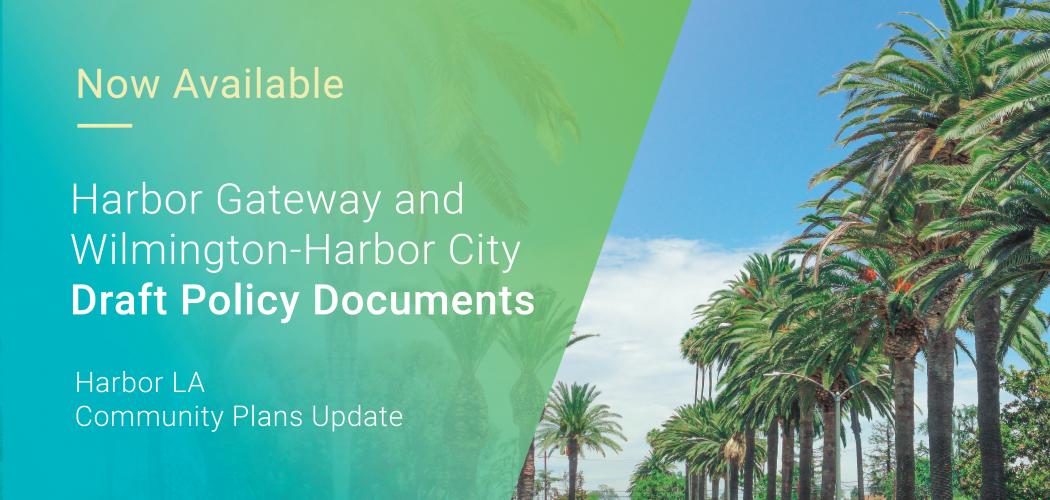
| Wilmington-Harbor City Proposed Plan |
Interactive StoryMap |
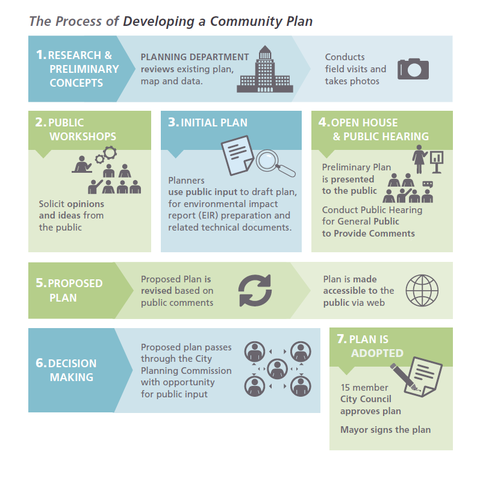
What is a Community Plan? |
| Harbor Gateway Proposed Plan |
New Zoning Code Video Series |
|
Note: More information on the new Harbor LA Zones can be found under the Draft Plans tab.
City Planning hosted a bilingual Virtual Information Session & Public Hearing on November 9, 2023, then the Plans were considered and recommended for approval by the City Planning Commission on February 8, 2024. A recording of the Virtual Information Session & Public Hearing, as well as the Staff Recommendation Report and Exhibits considered by the City Planning Commission, can be viewed under “Past Events” on the Events tab.
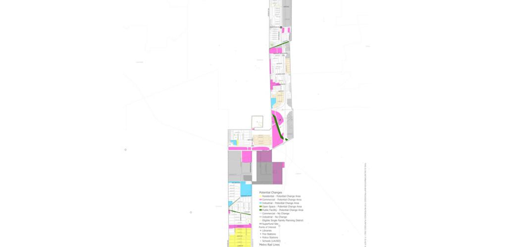
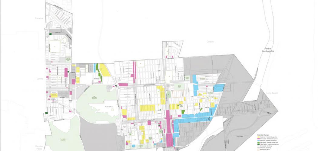
(click to enlarge image)
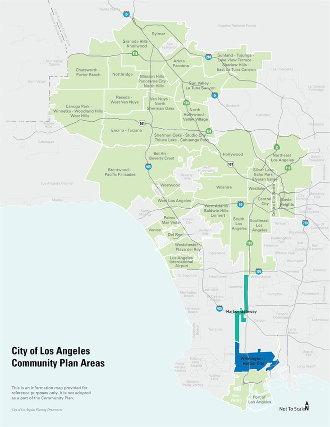
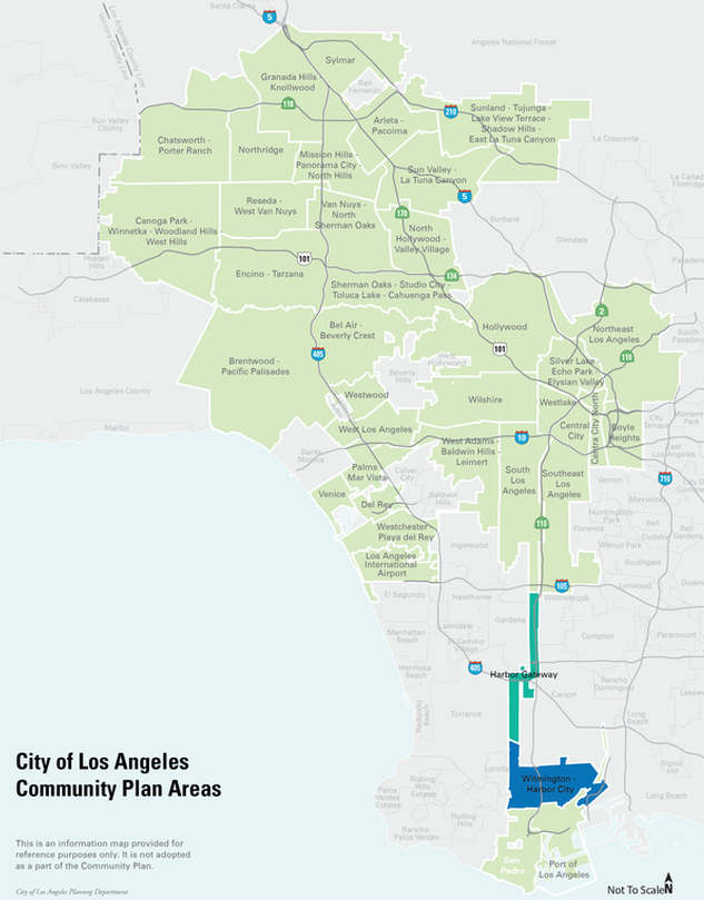
The Harbor LA Community Plans consist of two of the City’s 35 Community Plans: Harbor Gateway and Wilmington-Harbor City. Community plans constitute the Land Use Element of the General Plan, the long-range planning document that presents the goals and policies for the future of its neighborhoods.
The Los Angeles Department of City Planning updates Community Plans periodically to ensure that the land in each community is able to accommodate future generations of people and jobs in a way that is aligned with the environmental, land use and development goals for the region.
Community Plans establish goals and policies to guide future land use and development within each Community Plan Area. Community Plans consist of a Community Plan policy document and a General Plan Land Use Map. Land use designations establish the general location and intensity of different uses of land. Each land use designation has corresponding zones which regulate the size, shape, location, and use of buildings on a given property. The Community Plan Update is an opportunity to make needed changes or updates to land use designations and zoning for a community plan area. As part of this community plan update, new zoning developed through the comprehensive update of the City’s Zoning Code will be applied.
(click on button to view)
The Harbor Gateway Community Plan Area is situated in the southern part of Los Angeles, south of 120th Street and north of Sepulveda Boulevard. It is surrounded by the communities of Southeast Los Angeles, Wilmington-Harbor City, and the Cities of Gardena, Torrance and Carson.
The Harbor Gateway Plan Area contains approximately 3,229 acres. The Plan Area is a narrow corridor which links the City's harbor, San Pedro, Wilmington and Harbor City to the main body of the City. The Harbor Gateway Community Plan was last updated in 1995.
The Wilmington-Harbor City Community Plan Area is located between the planning communities of Harbor Gateway, San Pedro, and the Port of Los Angeles, and adjacent to the cities of Torrance, Lomita, Rancho Palos Verdes, Carson, Long Beach, and an unincorporated area of Los Angeles County.
The Wilmington-Harbor City Community Plan Area contains approximately 6,481 net acres. Most of the topography is level except for a small amount of varied, hillside terrain located in the southwest portion of the Plan Area, adjacent to Rancho Palos Verdes. The Wilmington-Harbor City Community Plan was last updated in 1999.
The Draft EIR was published on September 21, 2023. The 60-day public comment period ended on Monday, November 20, 2023 at 5:00 pm. You can review the DEIR either online or at:
The Harbor LA Community Plans Update will be utilizing new zones created through the City’s comprehensive zoning code update and implemented through the Harbor Gateway CPU and Wilmington-Harbor City CPU. To view zoning details for a specific property or address, please visit the Interactive Zoning Map.
Please note: The Downtown Community Plan will bring forward for adoption the New Zoning Code through Council File 22-0617. See the new Zoning Code Project Update for a draft of all Articles, which are currently in the Form & Legality process. The Boyle Heights Community Plan will introduce additional districts and standards into the new Zoning Code through Council File 23-0861.
The Harbor LA Community Plans will bring forward the unique zones and standards, that have not already been introduced with the Downtown and Boyle Heights Community Plans, to implement the Harbor LA Community Plans through the amendment below.
New Zoning Code
For additional Zoning Articles, as well as rules, regulations, and definitions, please see the New Zoning Code page.
In an effort to make information on the Harbor LA Community Plans Update Program more accessible to a wide array of stakeholders, we have developed a five-part video series that provides an overview of the Community Plan Update Program and the Proposed Zoning Tools. Please click on the links below to view any of the videos in our five-part video series. You can sign-up for Virtual or In-Person Office Hours using this link.
COMMUNITY PLAN POLICY DOCUMENTS
Proposed Plans - 2024
Preliminary Draft Plans - 2023
Preliminary Draft Plans - Spring 2022
Draft Plans (text-only) - Summer 2021
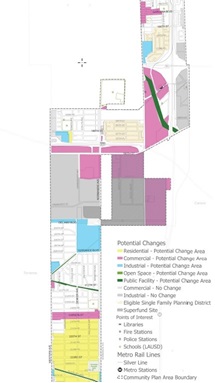
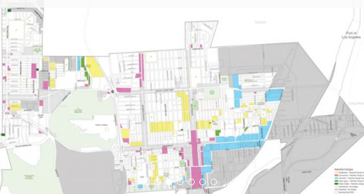
OCTOBER 2020 - DRAFT LAND USE MAPS - CONSULT PHASE
Review the Draft Land Use Maps presented in the Harbor LA Interactive Storymap.
MAY 2019 COMMUNITY WORKSHOPS - SHARE PHASE
Review the Draft Land Use Recommendations shared at the May 2019 Community Workshops.
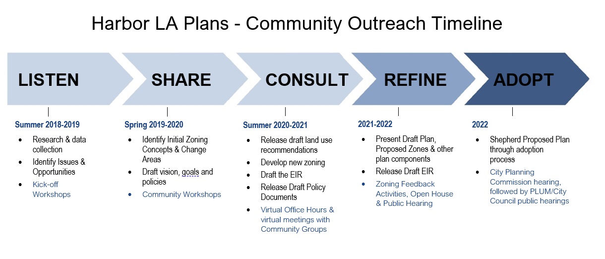
The Harbor LA Community Plans Update is a multi-year program which began in Summer 2018. Please refer to the Outreach Timeline below to see the major steps in the process.
Draft Land Use Maps with Correspondence Tables - 2024
Proposed Zoning Maps - September 2023
Draft Land Use Maps with Correspondence Tables - 2023
Draft Land Use Maps - 2023
Draft Land Use Maps - 2021
Draft Land Use Maps - October 2020
A state law requiring state and local agencies to analyze the potential impacts of their actions on the environment, disclose their findings to the public, and to mitigate impacts where feasible.
The Land Use Element of the General Plan consists of 35 Community Plans. Each focuses on a particular area or community in the City (e.g., Harbor Gateway Community Plan).
The number of residential units permitted per acre of land.
Type of environmental review prepared when the City determines that a project may potentially have significant environmental impacts.
The ratio of the gross floor area of a building to the area of the lot where it is located. (This video explains FAR.)
Part of the zoning that establishes the height and FAR limitations.
Development of vacant or underutilized land within urban communities that are nearly fully developed.
A project that combines compatible uses within the same structure or parcel, such as residential uses above ground floor commercial space.
A law or statute enacted by a city government. Zoning is established by ordinance.
A permanent committee of five or more citizens who are appointed by the City to review matters related to planning and development.
A minimum distance required by zoning to be maintained between two structures or between a structure and property lines (also known as a yard).
Development located near transit. The City’s General Plan encourages locating new housing and businesses near transit to provide convenient alternatives to car travel (e.g., walking, bicycling, taking public transportation).
The type of activity or development permitted in a specific zone.
Zoning determines the uses permitted on a parcel and provides regulations for development, including height, bulk, and setbacks.
 Email Subscription
Sign up for notifications about the Harbor LA Community Plans update by filling out the form at the bottom of this page.
 Social Media
The Los Angeles City Planning Department shares news and information through its Facebook, Twitter, Instagram, and YouTube accounts.

City of Los Angeles
Department of Cultural Affairs
Department of Building & Safety (LADBS)
Department of Public Works (DPW)
Bureau of Engineering (DPW)
Bureau of Sanitation (DPW)
Bureau of Street Lighting (DPW)
Bureau of Street Services (DPW)
Department of Recreation & Parks
Department of Transportation (LADOT)
Department of Water and Power (LADWP)
Los Angeles World Airports
Port of Los Angeles
LA Waterfront
Other Agencies
Southern California Association of Goverments (SCAG)
Los Angeles County Metropolitan Transportation Authority (Metro)
Los Angeles County Department of Region
General Plan Elements
Community Plans
re.code LA
Zoning Code (Chapter 1 of the Municipal Code)
Zoning Code Manual
Zoning Information and Map Access (ZIMAS)
Banning Park Historic Preservation Overlay Zone
Clean Up Green Up
Clean Up Green Up Ordinance
South Los Angeles Sales Specific Plan
Ponte Vista at San Pedro Specific Plan
Other City Resources
City of Los Angeles Charter
Los Angeles Municipal Code (LAMC)
Frequently Called Numbers
Email
HarborGateway@lacity.org
Wilmington-HarborCity@lacity.org
planning.harborlaplans@lacity.org
Address
Los Angeles City Hall
200 N. Spring Street, Room 667
Los Angeles, CA 90012