
The Westside Community Plans Update team is excited to announce the release of the 2024 Draft General Plan Land Use Storymap!
The StoryMap showcases the draft General Plan Land Uses that address issues such as housing, transportation, climate change, and equity across the westside region. Thank you for all the input received from community members and groups who have engaged in the process so far. We look forward to continued feedback and engagement from all stakeholders to continue informing future drafts of the Community Plans, and we will be taking feedback throughout the entire Community Plan Update process.
The StoryMap published today features updated draft General Plan Land Use Designations for the Palms-Mar Vista-Del Rey, West Los Angeles, Westchester- Playa del Rey, and Venice Community Plan Areas including the coastal zone, based on feedback received after the publication of the Westside Community Planning Advisory Group (WCPAG) meeting materials throughout 2023. The interactive map highlights the land use and zoning regulations, such as Height Limits, Floor Area Ratio (FAR), and Density, that are permitted at a parcel level. The StoryMap reflects a wide range of stakeholder input received through outreach meetings held virtually and in person, as well as through received written comments.
View the StoryMap here: StoryMap
In addition to the StoryMap, Draft General Plan Land Use maps are available to view for each of the four Community Plan Areas, as well as a Summary of Refinements made to the Subareas from the 2023 Drafts, and a high level summary of each Community Plan.
Los Angeles City Planning (LACP) is pleased to announce the formation of the 2022 Westside Community Plans Advisory Group (WCPAG).
The 52-member Advisory Group is composed of a diverse group of community leaders, residents, community based organizations (CBO), advocacy groups, business leaders, Neighborhood Councils, Business Improvement Districts (BIDs), youth, housing development experts, and professionals from various planning-related fields.
The Advisory Group, which is not a decision making body, will assist the LACP Westside Community Plans Update team in evaluating initial draft community plan materials, such as new land use maps, zoning, and draft policies. These efforts will help address a wide variety of topics, including housing, tenant rights, homelessness, climate change, mobility, historic preservation and cultural resources, sustainability, and other critically important issues facing the Westside Communities.
Please see meeting materials here: Meeting Materials
The Venice Community Plan Update Team, in coordination with the City of Los Angeles’ Office of Historic Resources, and Rincon consultants are conducting a resurvey of historic resources in the Venice Plan area.
We invite you and your neighbors to help us identify resources in your community with historic or cultural significance. If interested, please fill out the survey below.
My Historic Venice Mi Histórico Venice
For inquiries please contact: Eva Chang-Person eva.chang-person@lacity.org. Click here for more information on the Office of Historic Resource. Click here for more information on the Office of Racial Justice, Equity and Transformative Planning.
The Westside Planning Team presented draft land use concepts online for each of the four Community Plan areas: West Los Angeles, Palms-Mar Vista-Del Rey, Venice, and Westchester-Playa del Rey. Webinars took place July 14, July 16, and July 21 (Spanish). Thank you to everyone who submitted feedback on the Draft Concepts.
Review Draft Concept Webinar Materials Here
Community Plans shape the environment by determining how neighborhoods use land. Los Angeles City Planning updates its Community Plans periodically to ensure that each community’s land can accommodate future generations in a way that aligns with environmental, land use, and development goals for the region. An updated Community Plan lays a solid foundation for the future of a neighborhood.
Q: What are Community Plans? Why update them?
A: The City has 35 Community Plans. Taken together, they make up the Land Use Element of the City’s General Plan.
Community Plans establish goals and policies to guide future land use and development within each plan area. Plan maps identify where uses such as jobs, housing, and open space will be located. It is important to keep the City’s Community Plans up to date because they:
Click the button below to watch a video about Community Plans.
![]()
Q: What are the Westside Community Plans?
A: They are the Community Plans for four areas in the Westside: West Los Angeles, Venice, Palms – Mar Vista – Del Rey, and Westchester – Playa del Rey.
For information about the Venice Local Coastal Program Update, click the button below.
![]()
Q: How can I get involved?
A: There are many ways to get involved. Please participate so your values and vision are reflected in the Community Plan Updates.
Attend a meeting or event (check our Events page).
Sign up for email updates (click Get Involved below).
Sign up for Email updates
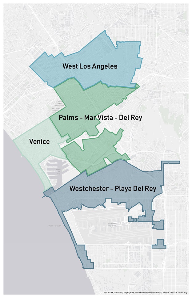
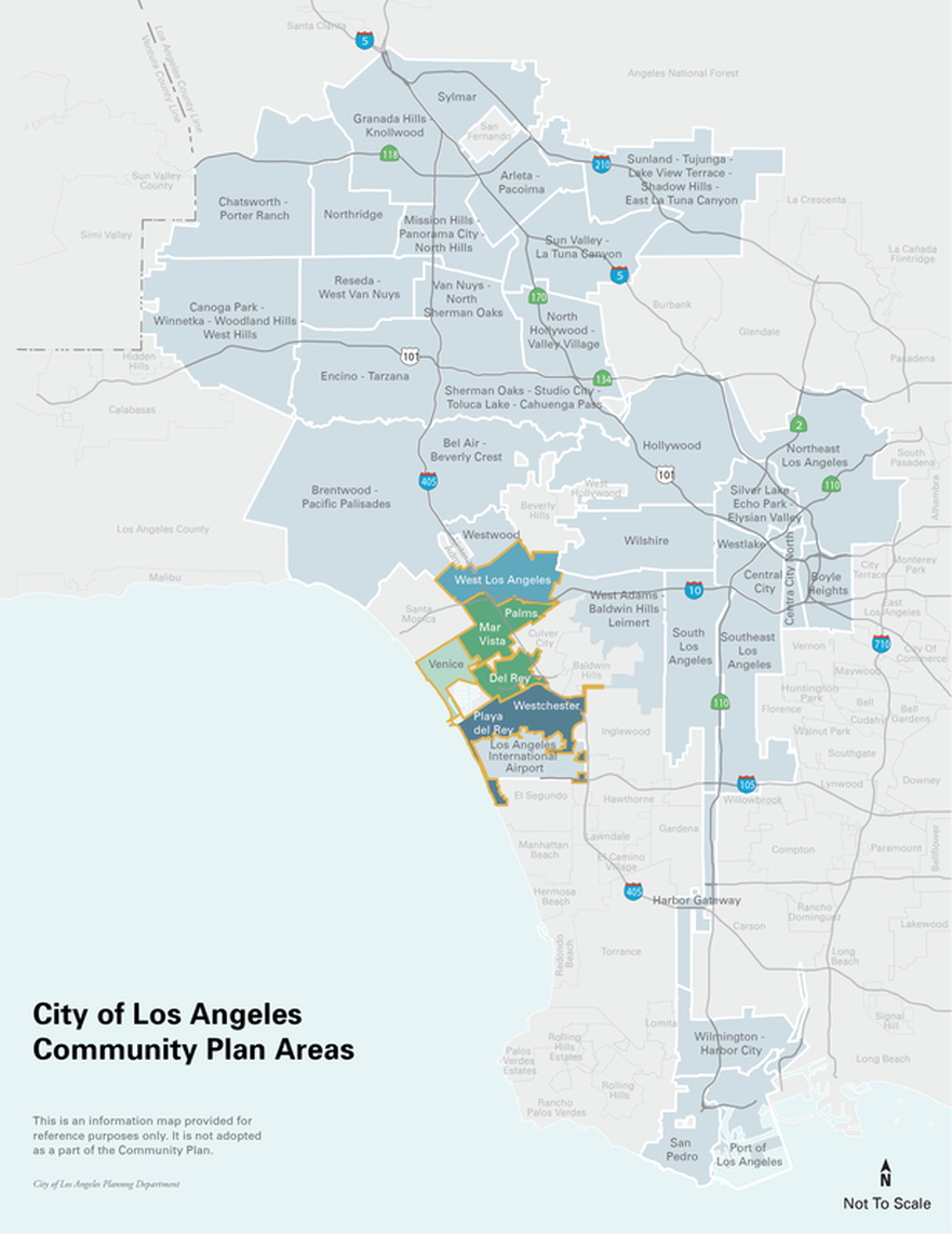 The City is currently updating the Community Plans for four areas on the Westside: West Los Angeles, Venice, Palms – Mar Vista – Del Rey, and Westchester – Playa del Rey. Updates to the Community Plans for the remaining Westside areas (Westwood, Brentwood – Pacific Palisades, and Bel Air – Beverly Crest) will follow.
Choose a plan below to learn more about the area it covers. This page links to the existing Community Plans and land use policy documents for each area.
Look up the Community Plan Area for any street address in Los Angeles here. The area will appear as the first entry in the “Planning/Construction” category.
(Click to enlarge image)
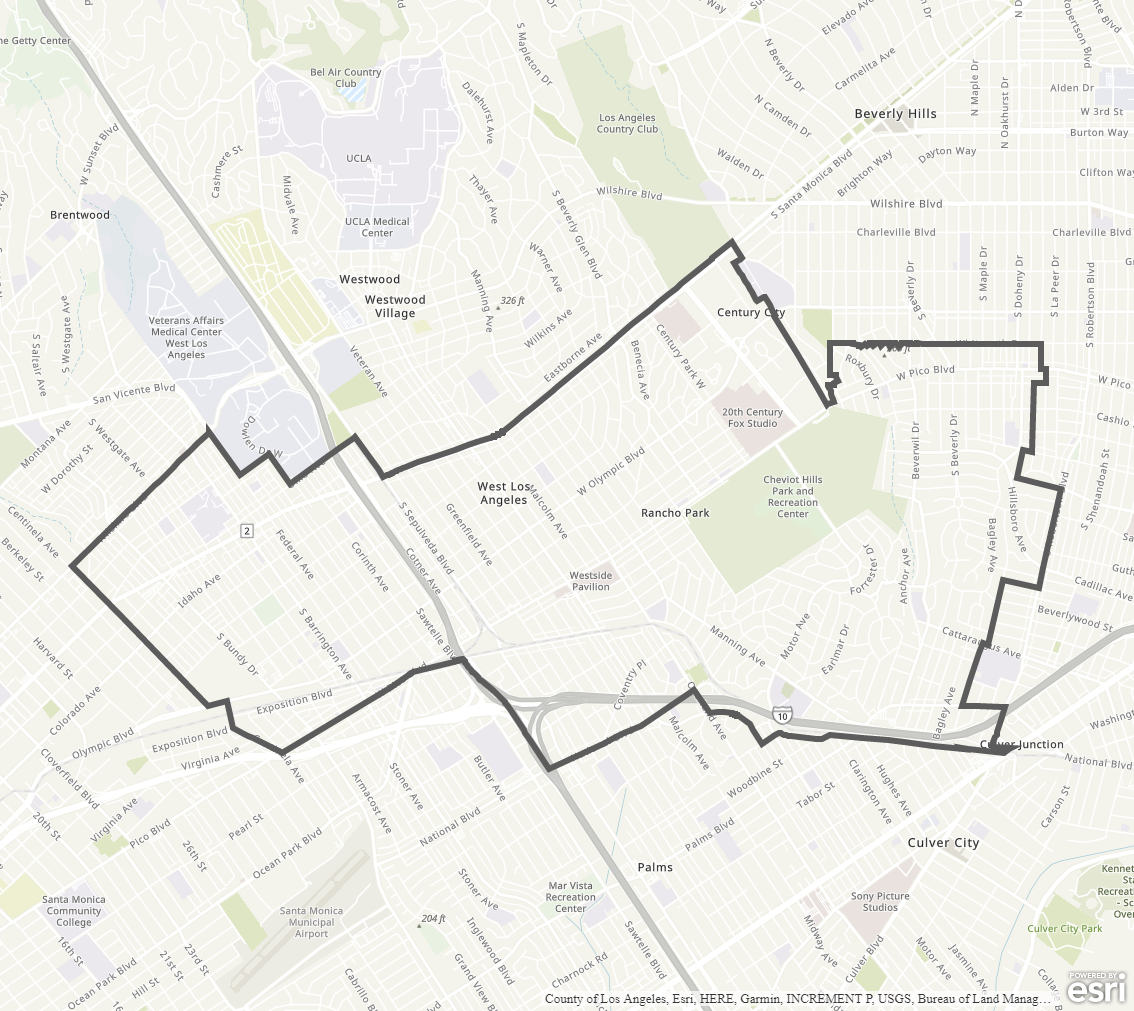
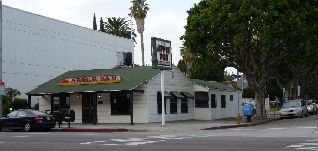
The West Los Angeles Community Plan Area (CPA) is located in the western portion of the City of Los Angeles. It is generally bounded by Centinela Avenue on the west, Wilshire Boulevard and Santa Monica Boulevard on the north, National Boulevard, Pico Boulevard, and Exposition Boulevard on the south, and Durango Avenue, Robertson Boulevard, and Canfield Avenue on the east.
The West Los Angeles CPA is bounded by the communities of Westwood, Brentwood, Century City, Rancho Park, Palms, Mar Vista, and the city of Santa Monica.
Community Plan
West Los Angeles | Land Use Map
Specific Plans
Century City North
Century City South
Sepulveda Corridor
West Los Angeles Transportation Improvement and Mitigation Plan (update in progress)
Community Design Overlay District
West Pico Boulevard
West Wilshire Boulevard
Westwood-Pico NOD
Streetscape Plans
Expo Corridor (in progress)
Livable Boulevards
West Los Angeles Demographic Profile
Plan Area at a Glance 2018
Demographic Report 2019
Demographic Report 2018
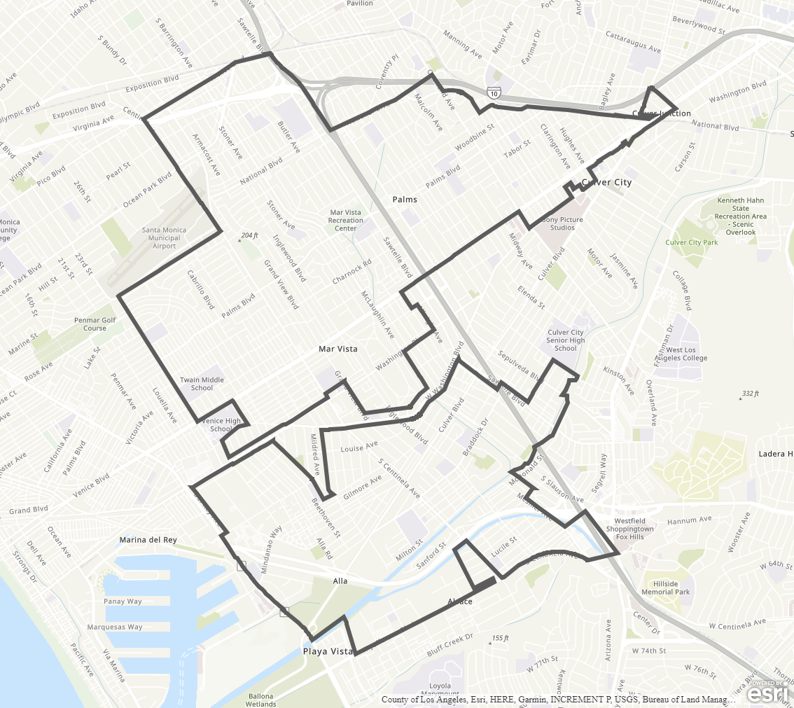
The Palms – Mar Vista – Del Rey Community Plan Area (CPA) contains 5,257 acres, approximately two percent of the land in the City of Los Angeles. The area is located in the western portion of Los Angeles with roughly irregular boundaries. The terrain varies from flat land in the southern section to rolling hillside in the north.
The community is bisected by a narrow strip of the City of Culver City along Washington Boulevard. The northern section proceeding in a clockwise direction is bounded by the City of Santa Monica, Pico Boulevard, southerly along the San Diego Freeway up to National Boulevard, Exposition Boulevard and Southern Pacific Railroad Company line, Robertson Boulevard up to National Boulevard, Venice Boulevard, Washington Boulevard, City of Culver City, and Walgrove Avenue.
Community Plan
Palms-Mar Vista-Del Rey | Land Use Map
Specific Plans
Coastal Transportation Corridor
Exposition Corridor Transit Neighborhood Plan
Glencoe/Maxella
Playa Vista Area B/C/D
West Los Angeles Transportation Improvement and Mitigation Plan
Community Design Overlay District
West Pico Boulevard
Historic Preservation Overlay Zone
Gregory Ain Mar Vista Tract
Streetscape Plans
Expo Corridor
Livable Boulevards
Palms-Mar Vista-Del Rey Demographic Profile
Plan Area at a Glance 2018
Demographic Report 2019
Demographic Report 2018
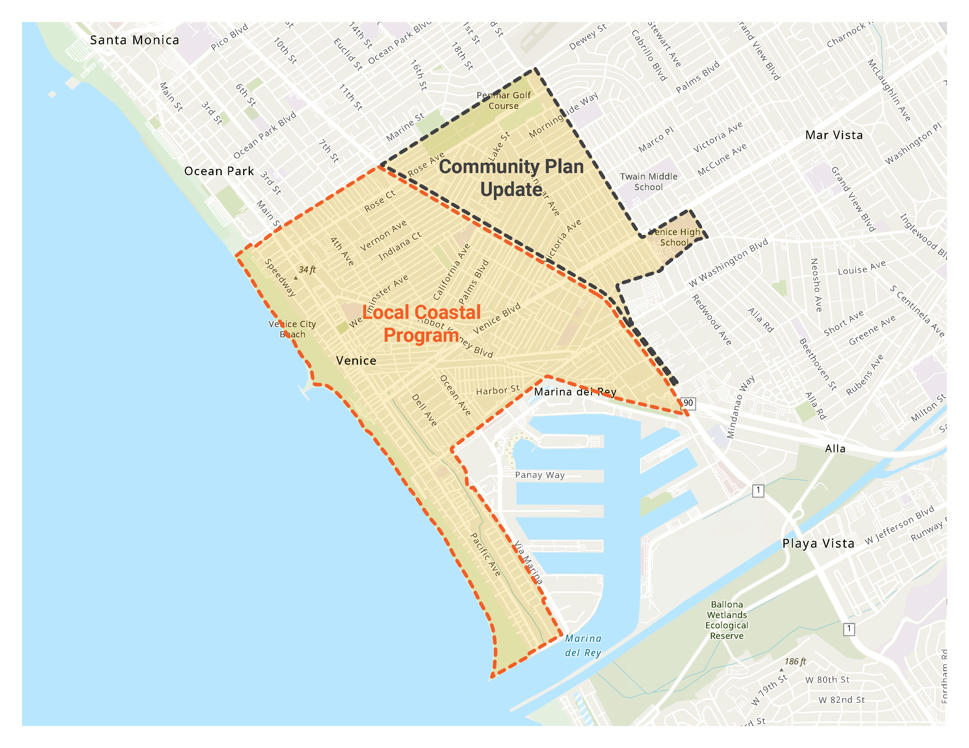
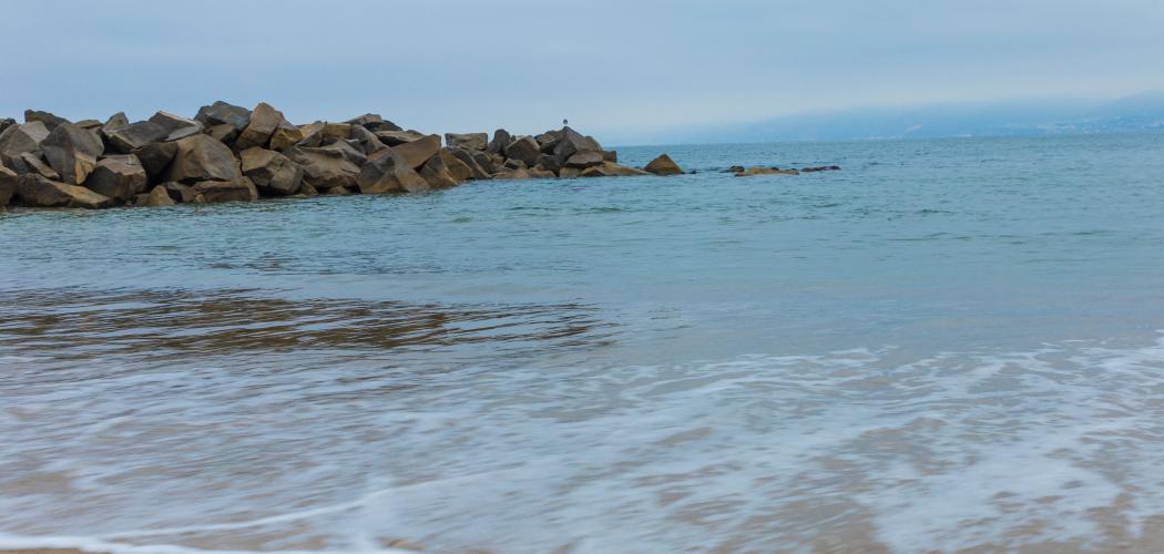
85% of the Venice Community Plan Area is located in the Coastal Zone and is subject to California Coastal Act regulations. In order to comply with the Coastal Act, Los Angeles City Planning is undertaking a multi-year effort, with public input, to prepare, adopt, and certify the Venice LCP as the coastal planning tool for the area. The LCP establishes land use, development, natural resource protection, coastal access, and public recreation policies for the Venice Coastal Zone. For more information, please visit the Venice Local Coastal Program website:
![]()
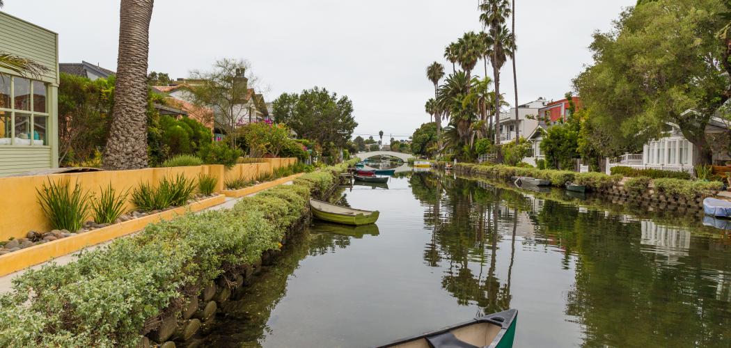
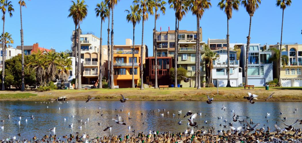
The Venice Community Plan Area (CPA) contains approximately 2.061 acres, representing 0.7 percent of the land in the City of Los Angeles. Located in the western portion of Los Angeles, it contains the world-famous Venice Beach and Boardwalk that stretch from Marina Court on the north to Yawl Street on the south. The Plan Area is bounded to the north by Marine Court and Dewey Street, adjoining the City of Santa Monica. It extends in an irregular fashion from the Pacific Ocean eastward to Walgrove Avenue, Beethoven Street, and Del Rey Avenue, bordering the Palms – Mar Vista – Del Rey Community Plan Area, parts of Culver City and Los Angeles County, and Marina Del Rey.
It is surrounded by the communities of Westwood, Brentwood – Pacific Palisades, Palms – Mar Vista – Del Rey, West Adams – Baldwin Hills – Leimert, and Wilshire; by the Cities of Culver City, Santa Monica, and Beverly Hills; and by the County of Los Angeles.
Venice Community Plan
Venice | Land Use Map
Venice Coastal Zone Land Use Plan
Venice Coastal Zone Land Use Plan
Venice Community Specific Plans
Coastal Transportation Corridor Specific Plan
Glencoe/Maxella
Oxford Triangle
Venice Coastal Zone Specific Plan
Venice Coastal Zone Specific Plan
Community Design Overlay District
Lincoln Boulevard
Venice Demographic Profile
Venice Historical Timeline
Plan Area at a Glance 2018
Demographic Report 2019
Demographic Report 2018
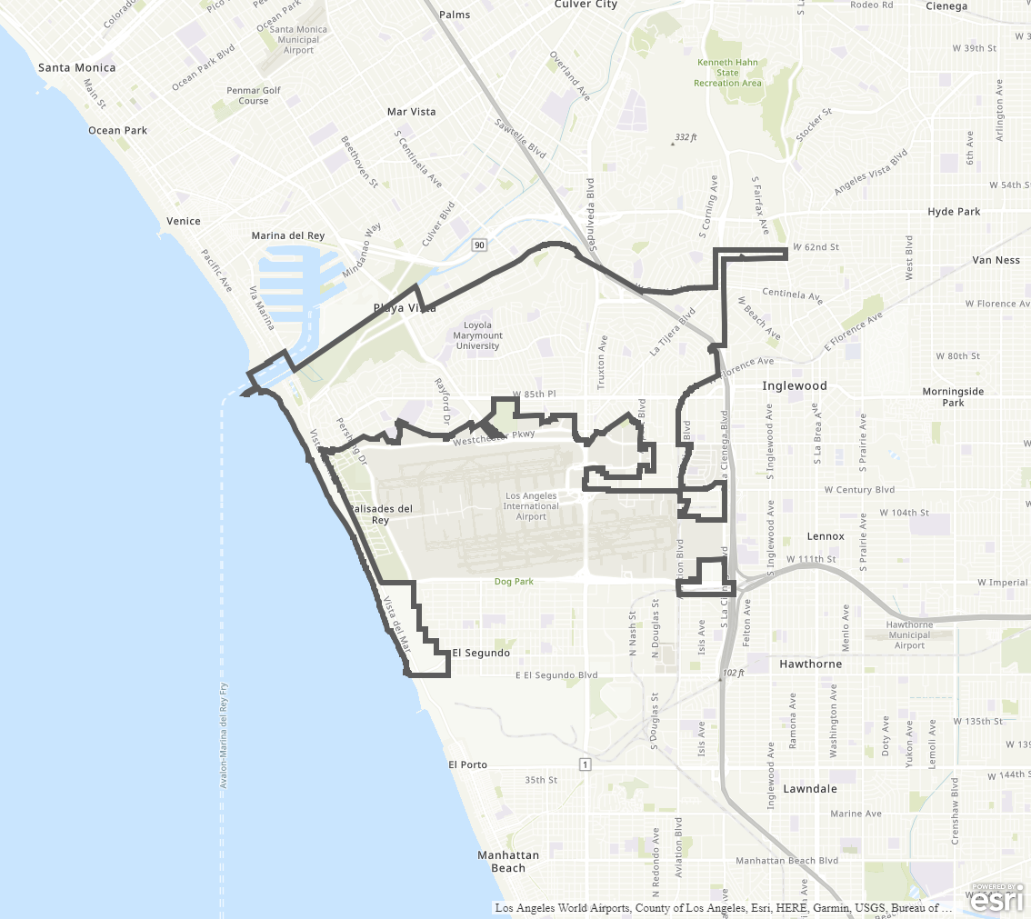
The Westchester – Playa del Rey Community Plan Area (CPA) is situated in the western portion of the Los Angeles Basin, adjacent to Los Angeles International Airport (LAX). It is located south of the communities of Palms – Mar Vista – Del Rey and Venice, and is adjacent to the Cities of Culver City, Inglewood, and El Segundo, and the Los Angeles County unincorporated areas of Del Aire, Ladera Heights, Lennox, and Marina del Rey.
The Westchester – Playa del Rey CPA is generally bounded by Centinela Avenue, La Brea Avenue, the City of Los Angeles’s boundaries with the unincorporated County of Los Angeles, the City of Inglewood, the City of El Segundo, Dockweiler State Beach, Ballona Creek, Bay Street, and Jefferson Boulevard.
Community Plan
Westchester-Playa Del Rey | Land Use Map
Specific Plans
Coastal Bluffs
Coastal Transportation Corridor
Glencoe/Maxella
Loyola Marymount University
Playa Vista Area B/C/D
Community Design Overlay District
Downtown Westchester
Loyola Village
Streetscape Plans
Century Boulevard
Livable Boulevards
Westchester-Playa Del Rey Demographic Profile
Plan Area at a Glance2018
Demographic Report 2019
Demographic Report 2018
Each city within the state of California is required to adopt a General Plan comprising seven required elements, including a Land Use Element. In Los Angeles, the Land Use Element is divided into 35 Community Plans, each with a policy document and a map of land use designations (such as residential, commercial, industrial, and open space). The Community Plans function as blueprints to guide growth in neighborhoods, providing specific policies and strategies to achieve each community’s vision and the broader objectives of the General Plan.
Community Plans are important because they:
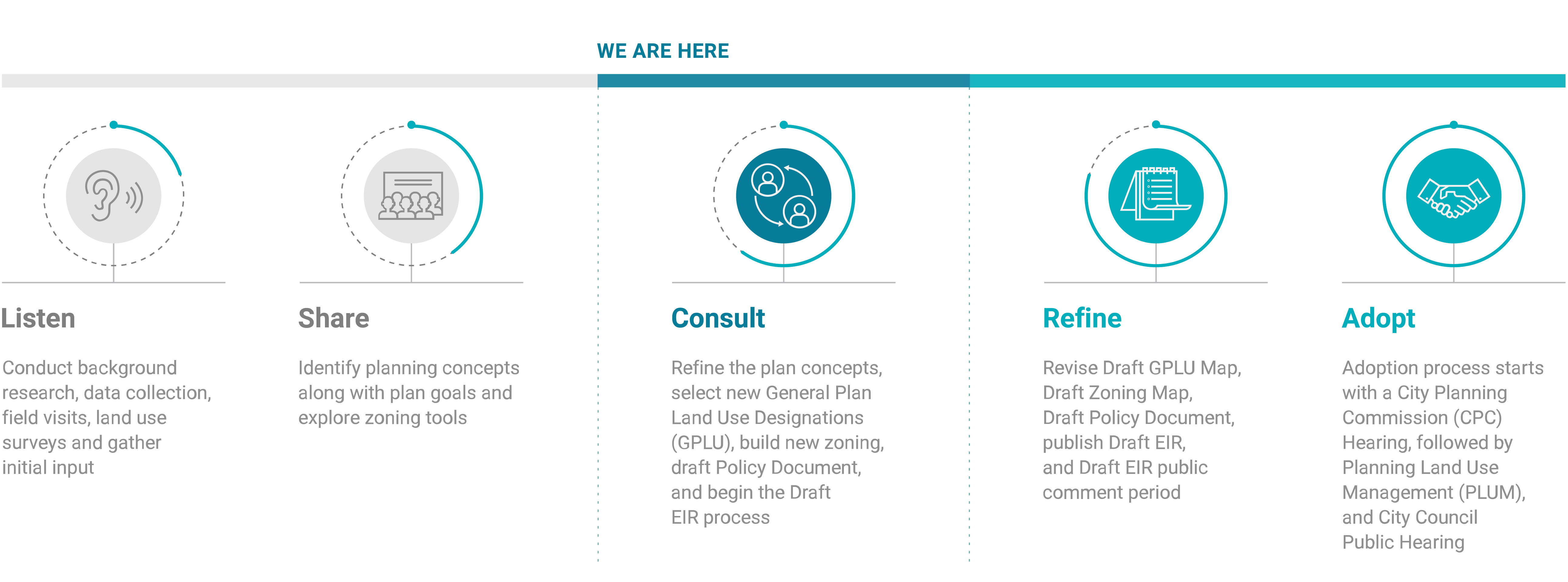
Mayor Garcetti and the City Council have committed to updating all 35 of the City’s Community Plans by 2024 to provide more contemporary land use plans and policies for all Angelenos. As part of the Department’s strategy and process for updating all of the Community Plans within this time frame, it is updating the Westside Community Plans between 2018 and 2021.
During the update, the Department of City Planning will:
The horizon for the Community Plans is 20 to 25 years into the future.
What is the end product?
This Community Plan update process results in four separate final products:
re:codeLA is the Department’s program to comprehensively revise the City of Los Angeles’s Zoning Code. The revision is meant to simplify use and development regulations while making the development process more efficient and predictable.
The Department is moving away from creating new Specific Plans or overlays within Community Plan areas. Instead, the preferred approach is to incorporate unique neighborhood characteristics or development standards into the new zoning which will have expanded regulatory controls. Existing Specific Plans will continue to be enforced and will be evaluated at a later time for updates or incorporation into the new zoning.
Created as a result of Measure JJJ, approved by voters in 2016, the TOC Program establishes a set of incentives, such as density and floor area increases, for qualifying residential and mixed-use projects located near major transit stops. To qualify for incentives, TOC projects are required to include a set percentage of affordable housing. While the TOC regulations have been implemented citywide, there is flexibility for tailoring as we update Community Plans. These regulations will be captured as part of the new zoning through re:code and will include both general development regulations and site-specific regulations.
The Los Angeles City Planning Department will continue to engage with communities and community stakeholders through meetings, public events, and online webinars. The Department also regularly emails notifications and announcements to its mailing list. Additionally, Neighborhood Councils are having discussions about the Community Plans, and all stakeholders are encouraged to participate in those conversations.
Reach out to the team by emailing us at planning.thewestside@lacity.org.
Where can I get more information?
Explore the Department’s website to find current Community Plans, public outreach events, documents, and other general updates.
Find us on Facebook at facebook.com/planningthewestside
Find us on Twitter at https://twitter.com/Planning4LA
Find us on Instagram at https://www.instagram.com/planning4la/?hl=en
Find us on Youtube at https://www.youtube.com/c/Planning4LA/featured
Download FAQ PDF
Help plan the Westside! The Community Plan update process includes numerous opportunities to participate. The timeline below provides a tentative schedule of major public outreach events. Please join our email list and check the News tab for the latest announcements.
(Click to enlarge image)
Click here to download timeline

The Westside Community Plans and Venice Local Coastal Program (LCP) Teams are excited to announce that we will be joining all the CicLAvia enthusiasts on Sunday April 21, 2024 on Venice Boulevard!
LA City Planning will be hosting a booth from 9am-4pm at the Venice Beach Hub, located at 121 Windward Ave., Venice CA 90291.
Please come by City Planning’s booth to meet staff and learn more about Planning the Westside and Local Coastal Program…
READ MORE AND VIEW MATERIALS
Planning staff is seeking assistance from a diverse group of community leaders to help advise the Westside Community Plans Update. We are forming an advisory group: The Westside Community Plans Advisory Group (WCPAG) and we invite those with specialized knowledge and a desire to help further shape the zoning and policy outcomes for the Westside Community Plans Update to submit an application.
Our previous email blast contained an RSVP link that did not work. We have resolved the issue and apologize for any inconvenience.
Hello! We hope that you are staying safe and healthy.
A resurvey of historic resources in the Venice Coastal Zone Area is being conducted as part of the Venice Community Plan Update effort. The Los Angeles City Planning’s (City) survey team is seeking your input.

During the months of June and July, the Westside Planning Team conducted a Community Plan Workshop in each plan area : West Los Angeles, Palms-Mar Vista-Del Rey, Westchester-Playa del Rey, and Venice. These workshops brought residents and planners together to review selections of land use ideas based upon input received from community stakeholders over the past year. During these workshops, we had the opportunity to confirm whether we accurately captured community concerns and land use considerations. We also received additional feedback. Thank you to everyone who attended!
READ MORE +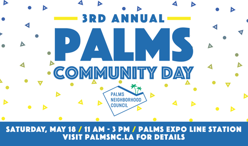
This Saturday, May 18, the Palms Neighborhood Council is hosting their 3rd annual Palms Community Day. The Westside team will be present to share more about the Westside Community Plans Update. Be sure to stop by and say hello!
What: 3rd Annual Palms Community Day
When: Saturday, May 18, 2019, 11 am - 3 pm
Where: Palms Expo Line Station
Why: Food trucks, live performances and more!
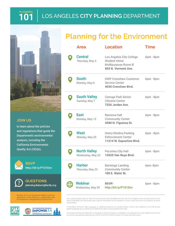
The Department of City Planning is presenting a series of Planning 101 training sessions during the month of May! The next meeting, taking place on Monday, May 20, 2019 will be in West Los Angeles at the Henry Medina Parking Enforcement Center.

In February 2019, the Westside Community Plans team participated in a series of Neighborhood Council Walking tours.
These walking tours, planned and conducted by the Neighborhood Council representatives, provided on-the-ground perspectives of issues and opportunities in the four community plan areas.
READ MORE +

On April 6th, 2019 the Westside Community Plans Update team will be hosting a visioning workshop at the Mar Vista Gardens Community Center. All residents are invited to attend to learn more about the Westside Community Plans Update and share your vision for your community. We hope you can join us!
When: April 6th, 2019, 10AM-12PM
Where: Mar Vista Gardens Community Center, 4909 Marionwood Drive
What: Visioning Workshop
Please see flyer for details.
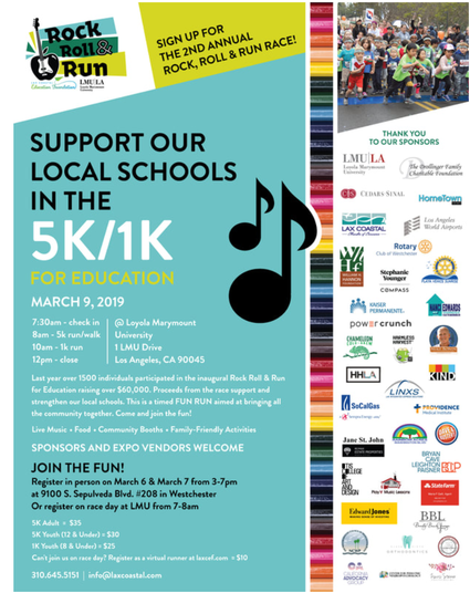
Come and hang out with the Westside Plans Update team at the second annual Rock Roll & Run this Saturday!
When: Saturday, March 9, 2019, 7:30am-12pm
Where: Loyola Marymount University campus, Westchester
What: Second Annual Rock Roll & Run for Education 5K
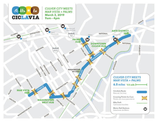
Grab your bike and helmet and join the Westside Plans Update team at CicLAvia this Sunday!
When: Sunday, March 3, 2019, 9am-4pm
Where: Palms Hub: 3311 Motor Ave, Los Angeles, CA 90034 (our booth will be on the west side of Motor Ave)
What: Culver City meets Mar Vista + Palms CicLAvia
We hope to see you there!

Join the Westside Community Plans Update team at the Mar Vista Art Walk! This is an opportunity to hear more about the community plan update process while also checking out local artists in the area. We hope to see you there!
When: Thursday, March 7th, 2019, 6:00-10:00 pm
Where: Venice Boulevard from Beethoven to Inglewood
What: Mar Vista Art Walk
Get more information at: marvistaartwalk.org
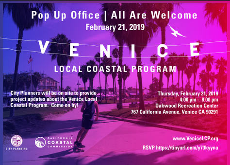
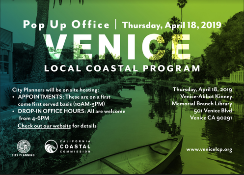
The Venice Local Coastal Program planning team will be hosting a "Pop Up" Office Hours in Venice.This is an opportunity for the community to engage with the Venice LCP team and project planners for the Venice area. Members of the Westside Community Plan Update team will also be present to answer questions about the Community Plan Update process. Your participation is important and we look forward to seeing you there!
When: Thursday, February 21, 2019, 4:00pm-8:00pm

The Westside Planning Team has reached a major milestone by successfully completing our initial phase of outreach activities for the Westside Community Plans Update Program!
The Kick-off events provided an excellent first opportunity for the community to identify issues and opportunities, as well as share their vision for their community. Over the next few months, staff will be reviewing and synthesizing these comments and use them to inform us while preparing concept ideas and policy statements for each of the four community plans.

Since officially launching the Westside Community Plans Update, the Westside Planning Team initiated a series of Neighborhood Council presentations! We have completed the process of meeting with the nine Neighborhood Councils located within the four Community Plan Areas, as well as the Westside Regional Alliance of Councils, to share information and answer questions about the community plan update process.
The Westside Planning Team has presented at the following Neighborhood Council meetings:

Westside Community Plans Update- Planning the Westside
Thank You for visiting our website!
The Department of City Planning has officially launched a three-year effort to update four Community Plans for the Westside region of Los Angeles: Palms-Mar Vista-Del Rey, Venice, West Los Angeles, and Westchester-Playa Del Rey.

The Venice Community Plan Update Team, in coordination with the City of Los Angeles’ Office of Historic Resources, and Rincon consultants are conducting a resurvey of historic resources in the Venice Plan area.
We invite you and your neighbors to help us identify resources in your community with historic or cultural significance.
My Historic Venice Mi Histórico Venice
For inquiries please contact: Eva Chang-Person
READ MORE +
Los Angeles City Planning (LACP) is pleased to announce the formation of the 2022 Westside Community Plans Advisory Group (WCPAG).
The 52-member Advisory Group is composed of a diverse group of community leaders, residents, community based organizations (CBO), advocacy groups, business leaders, Neighborhood Councils, Business Improvement Districts (BIDs), youth, housing development experts, and professionals from various planning-related fields.
The Advisory Group, which is not a decision making body, will assist the LACP Westside Community Plans Update team in evaluating initial draft community plan materials, such as new land use maps, zoning, and draft policies. These efforts will help address a wide variety of topics, including housing, tenant rights, homelessness,
READ MORE +
A resurvey of historic resources in the Venice Coastal Zone Area is being conducted as part of the Venice Community Plan Update effort. The Los Angeles City Planning’s survey team is seeking your input at a virtual Zoom meeting on November 16, 2020 at 5:30 pm. Please click on the link below for more information and to RSVP.
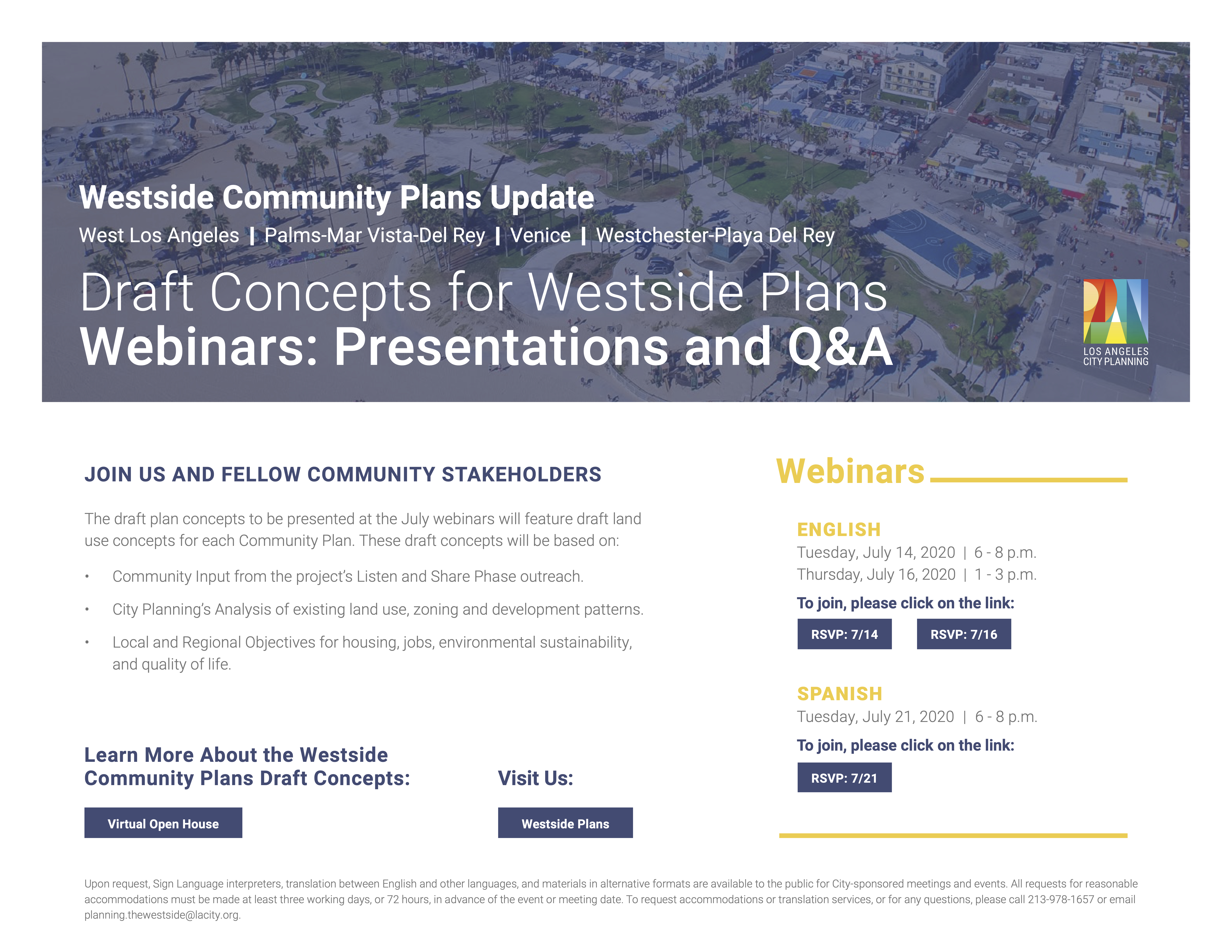
Webinar Recordings: Draft Concepts for Westside Plans
In July 2020, the Westside Planning Team presented draft land use concepts online for each of the four Community Plan areas: West Los Angeles, Palms-Mar Vista-Del Rey, Venice, and Westchester-Playa del Rey. Webinars took place on July 14, July 16, and July 21 (Spanish). A recording of each webinar can be viewed below.
Opening Regional Presentation - Westside Webinar
West LA Presentation - Westside Webinar
READ MORE +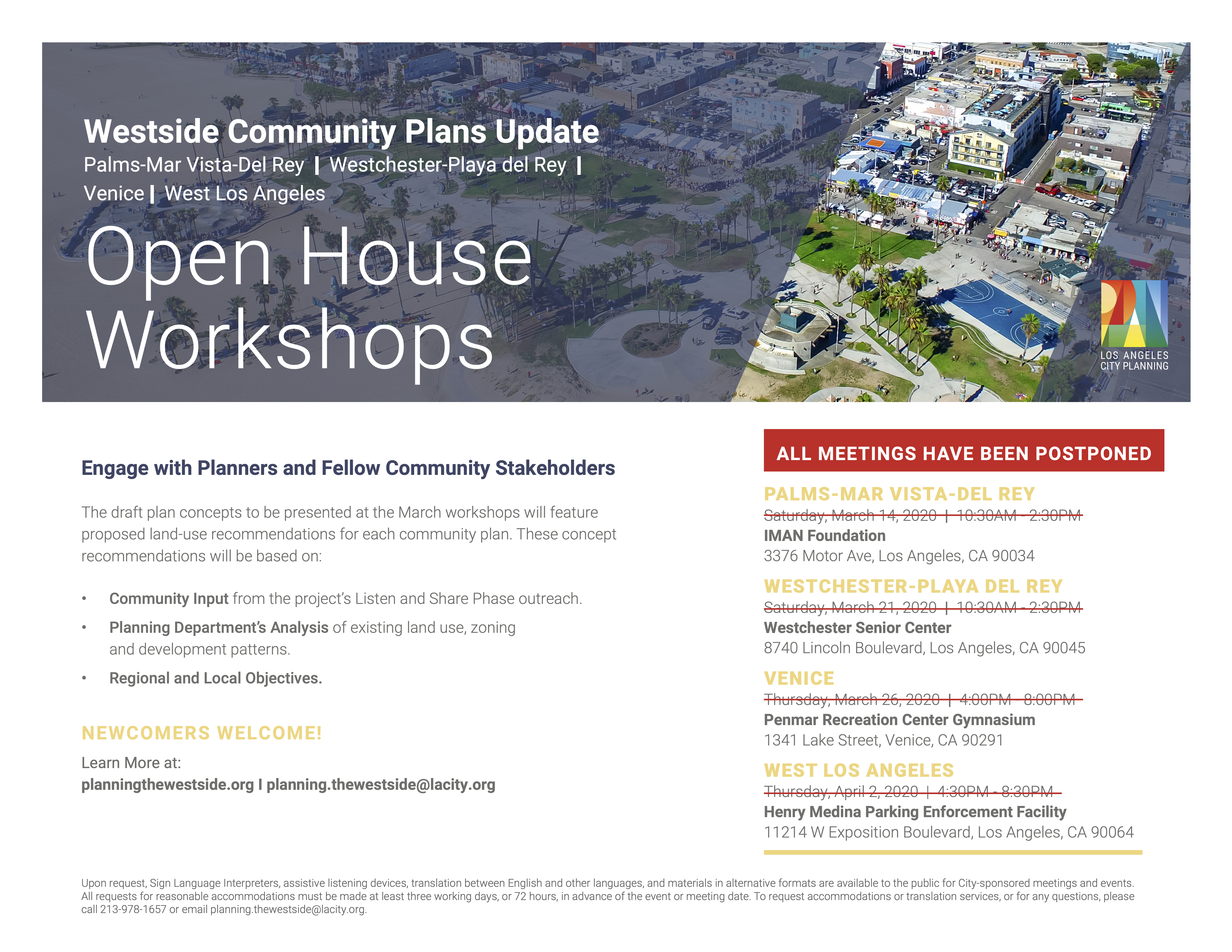

The Open House Workshops for the Westside Community Plans Update have been indefinitely postponed to prevent the spread of the coronavirus. Please check back for the rescheduled dates.
The LA City Westside Planning Team will host a series of Open House Workshops, which will include one workshop within each of the four community plan areas. Please note that information shared at each meeting will be specific to that community plan area.
At each workshop, the Westside Planning Team will
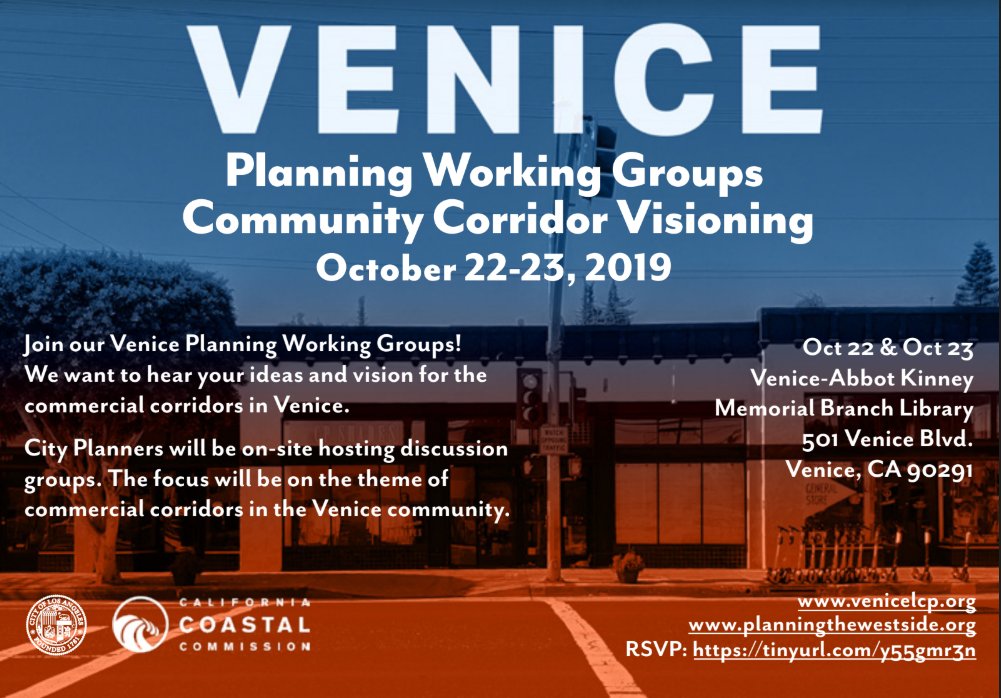
The Venice Planning teams - comprised of the Venice Local Coastal Program (LCP) and Venice Community Plan Update team (CPU) hosted four Working Sessions in October and one in November. The focus of the Working Sessions were three mixed-use corridors in Venice, including: Lincoln Blvd, Ocean Front Walk and Rose Ave.
Each Working Session included a presentation, a break out session and a feedback/share out activity. Three sessions were hosted on Tuesday, October 22 one session was held on Wednesday, October 23 and the last session was held on Thursday, November 22.
READ MORE +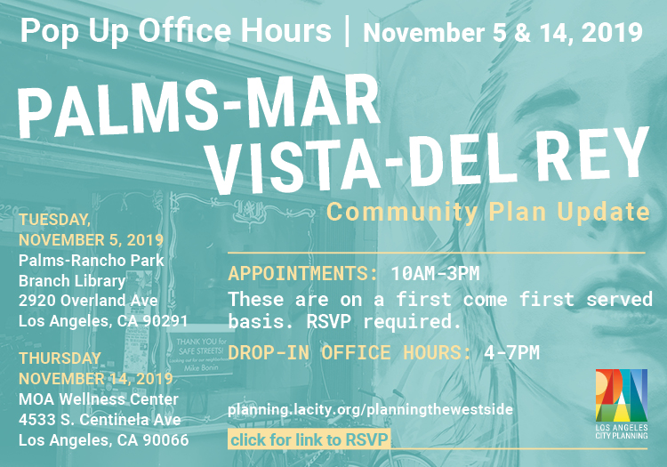
The Palms-Mar Vista-Del Rey Community Plan Update team hosted two Pop Up Office Hours events for individuals and groups in the Palms-Mar Vista-Del Rey area on November 5 and November 14, 2019. The focus of the Pop-Up Office Hours was to discuss the desired land use and zoning ideas for the commercial, residential, and industrial areas of the plan area. Members of the public were invited to make appointments or drop in.
READ MORE +
JOIN US as we share initial selections of land use ideas based upon the community input we have received over the past several months. What's your vision?
DROP IN anytime during the open house workshops. Let us know if we got it right and share more ideas. Newcomers welcome.
READ MORE +
JOIN US as we share initial selections of land use ideas based upon the community input we have received over the past several months. What's your vision?
DROP IN anytime during the open house workshops. Let us know if we got it right and share more ideas. Newcomers welcome.
READ MORE +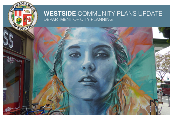
JOIN US as we share initial selections of land use ideas based upon the community input we have received over the past several months. What's your vision?
DROP IN anytime during the open house workshops. Let us know if we got it right and share more ideas. Newcomers welcome.
READ MORE +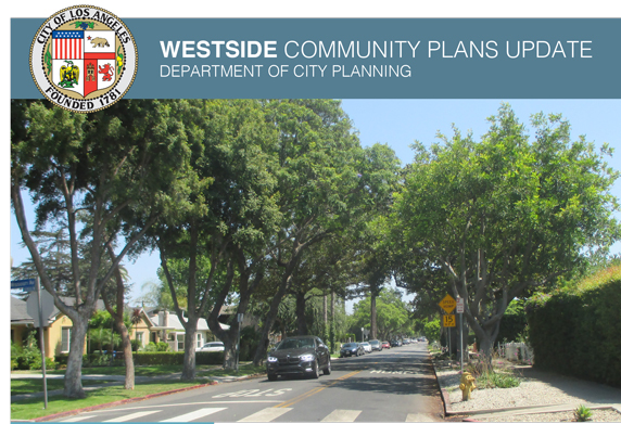
JOIN US as we share initial selections of land use ideas based upon the community input we have received over the past several months. What's your vision?
DROP IN anytime during the open house workshops. Let us know if we got it right and share more ideas. Newcomers welcome.
READ MORE +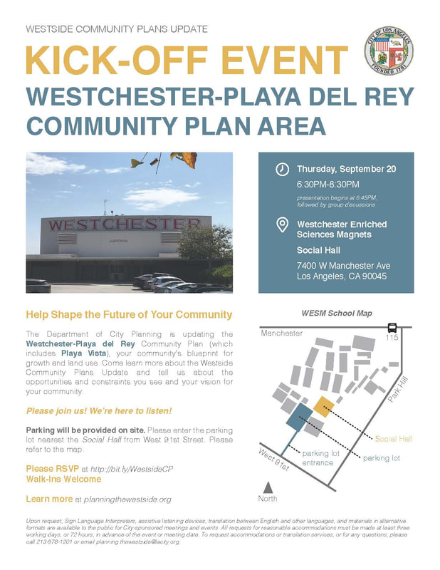
Help shape the future of your community
The Department of City Planning is updating the Westchester-Playa del Rey Community Plan (which include Playa Vista), your community's blueprint for growth and land use. Come learn more about the Westside Community Plans Update and tell us about the opportunities and constraints you see and your vision for your community.
Please join us, we're here to listen.
Parking will be provide on site. Please enter the parking lot nearest the Social Hall from West 91st Street.
READ MORE +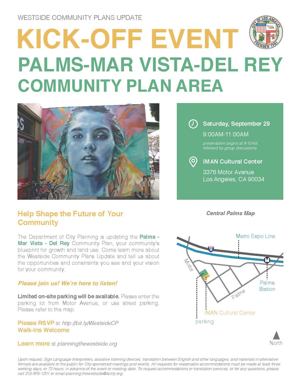
Help shape the future of your community
The Department of City Planning is updating the Palms-Mar Vista-Del Rey Community Plan, your community's blueprint for growth and land use. Come learn more about the Westside Community Plans Update and tell us about the opportunities and constraints you see and your vision for your community.
Please join us, we're here to listen.
Limited on-site parking will be available. Please enter the parking lot from Motor Avenue or use street parking.
READ MORE +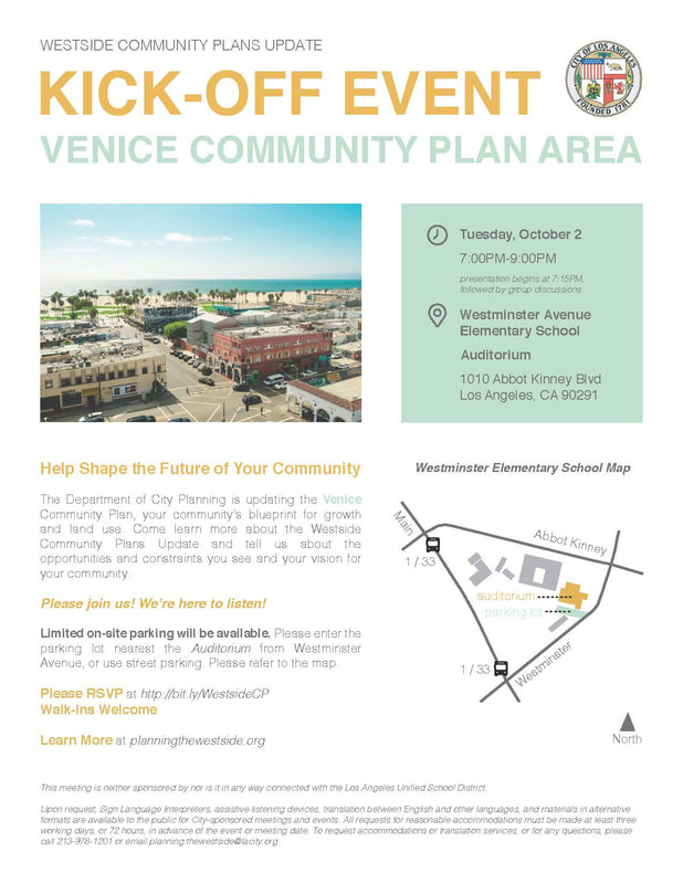
Help shape the future of your community
The Department of City Planning is updating the Venice Community Plan, your community's blueprint for growth and land use. Come learn more about the Westside Community Plans Update and tell us about the opportunities and constraints you see and your vision for your community.
Please join us, we're here to listen.
Limited on-site parking will be available. Please enter the parking lot nearest the Auditorium form Westminster Avenue, or use street parking.
READ MORE +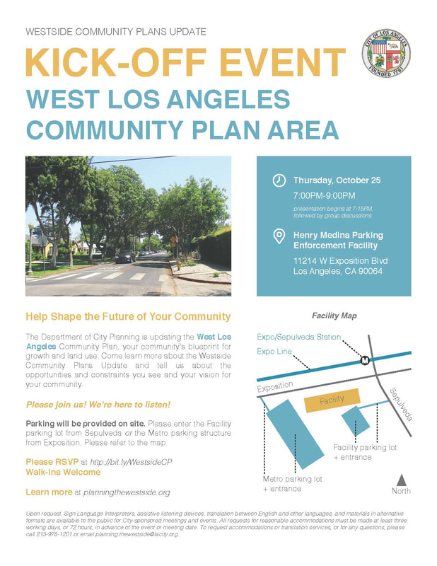
Help shape the future of your community
The Department of City Planning is updating the West Los Angeles Community Plan, your community's blueprint for growth and land use. Come learn more about the Westside Community Plans Update and tell us about the opportunities and constraints you see and your vision for your community.
Please join us, we're here to listen.
Parking will be provided on site. Please enter the Facility parking lot from Sepulveda or the Metro parking structure from Exposition. Walk-ins are welcome.
UPDATE: For materials from these events and a video recording of the live webinar.
How does the Community Plan Update affect you and your community? Learn how Community Plans work, what the update process is about, and how to get involved.
READ MORE +UPDATE: For materials from these Neighborhood Council presentations, click here.
Join the Westside planning team at your next Neighborhood Council meeting to learn more about the Community Plan Update process and how you can get involved.
For more information contact planning.thewestside@lacity.org.
READ MORE +
Find more information related to the Westside Community Plans at the links below.
Los Angeles City Planning Department
re:code LA
Zoning Code (Chapter 1 of the Municipal Code)
Zoning Code Manual
Zoning Information and Map Access (ZIMAS)
City of Los Angeles Open Data
City of Los Angeles Open Data Portal
City of Los Angeles GeoHub
City of Los Angeles Open Data-ArcGIS
County of Los Angeles Open Data Portal
Other City Resources
City of Los Angeles Charter
Los Angeles Municipal Code (LAMC)
NavigateLA
Council File Management System
Community Plans
West Los Angeles | Land Use Map
Palms-Mar Vista-Del Rey | Land Use Map
Venice | Land Use Map
Westchester-Playa Del Rey | Land Use Map
Specific Plans
Century City North
Century City South
Coastal Bluffs
Coastal Transportation Corridor
Glencoe/Maxella
Exposition Corridor Transit Neighborhood Plan
Los Angeles Airport/El Segundo Dunes
Loyola Marymount University
Oxford Triangle
Playa Vista Area B/C/D
Sepulveda Corridor
Venice Coastal Zone ( update in progress )
West Los Angeles Transportation Improvement and Mitigation Plan
Community Design Overlay District
Downtown Westchester
Loyola Village
West Pico Boulevard
West Wilshire Boulevard
Lincoln Boulevard
Pedestrian / Neighborhood Oriented District
Westwood-Pico NOD
Streetscape Plans
Century Boulevard
Expo Corridor
Livable Boulevards
Certified Coastal Plan Information
Venice Coastal Land Use Plan ( update in progress )
Environmental Process
Community Plan Environmental Process
City of Los Angeles
Department of Cultural Affairs
Department of Building & Safety (LADBS)
Department of Public Works (DPW)
Bureau of Engineering (DPW)
Bureau of Sanitation (DPW)
Bureau of Street Lighting (DPW)
Bureau of Street Services (DPW)
Department of Recreation & Parks
Department of Transportation (LADOT)
Department of Water and Power (LADWP)
Los Angeles World Airports
Port of Los Angeles
Housing Authority of City of Los Angeles (HACLA)
Los Angeles Housing Community Investment Department (HCID)
Other Agencies
Southern California Association of Goverments (SCAG)
Los Angeles County Metropolitan Transportation Authority (Metro)
Los Angeles County Department of Regional Planning
City Planning encourages Angelenos to participate in the update process so that the Community Plans reflect residents’ values and vision. Here are three easy ways to get involved.
Sign up for Email updates
Email: planning.thewestside@lacity.org
Phone Numbers
Palms - Mar Vista - Del Rey: Tereza Agesyan | (213) 756-1735
Venice: Eva Chang-Person | (213) 978-0628
West LA: Melissa Lim | (213) 756-1737
Westchester-Playa Del Rey: Charlotte Kings | (213) 978-3094
Physical Address
Los Angeles City Hall
200 N. Spring St, Rm 667
Los Angeles, CA 90012


